We spent two weeks in Arizona this year to get away from the rain (19 inches) and cold of January and February. We flew into Phoenix and spent a week there and then drove down for a week in Tucson.

We visited Taliesin West. If you never heard of it, it is the winter home designed and built by Frank Lloyd Wright. He bought the site in 1937 and started having students come out to study architecture. He actually made them live in tents while they did almost all of the labor building the houses! This is one of several fountains on the site.

Wright believed strongly in connecting his structures to the surrounding environment. This house in Arizona is made mostly from stone found on the property.

This is the "gathering room" (living room) where the students and Wright would gather in the evening to discuss their work and plan the next day. The furnishings were all designed by Wright. The chairs were actually very comfortable! The original roof was canvas and was replaced every year before they would come out for the winter.

We went to visit the Schnepf Farm in Queen Creek with Sandee, Alonda's college roommate. She lives in Sun City West. The Farm is still owned and operated by the original Schnepf family. The peach blossoms were supposed to be blooming and we wanted to see them. We went on the one mile "Peach Blossom Walk." After about a half mile, we had not seen a single blossom. We were giving up and turning around when the owner came by and picked us up in the golf cart and gave us a personal tour of the trees and the farm. He has eight varieties of peaches so they bloom and ripen at different times. They specialize in "you pick" farming and the owner says they get about 40,000 people a year!

We went to the Boyce Thompson Arboretum (also in the Queen Creek area). Jim was driving and had no idea how to obey this traffic sign!

All the plants and trees were labelled at the arboretum. It was in a desert canyon, and surprisingly green. There was a small river running through it. February is the month designated for their "Wildflower Walks."

The last thing we did with Sandee was go to a Spring Training baseball game in Peoria. This whole thing is a major industry in the Phoenix area. There were at least ten ball parks and fifteen major league teams and thousands of fans!

The game we attended was the Seattle Mariners vs the Chicago Cubs. Jim and Alonda live near Seattle and Alonda and Sandee were roommates in Illinois. You can tell this is not in Seattle because of all those people wearing shorts and sitting on the grass in the sunshine! By the way, zoom in and look at the score. It was only the 5th inning and Seattle was already losing badly. The final score was Cubs 16 Mariners 10.

This was our first stop near Tucson. Father Keno is a famous Jesuit in the Southwest. He started a mission on this site, but the Pope moved the Jesuits out and sent in the Franciscan monks. They never finished the building and it was being restored (again). Since they spent so long building these missions, it was not unusual for one bell tower to be different from the other. The building was quite beautiful inside, too.

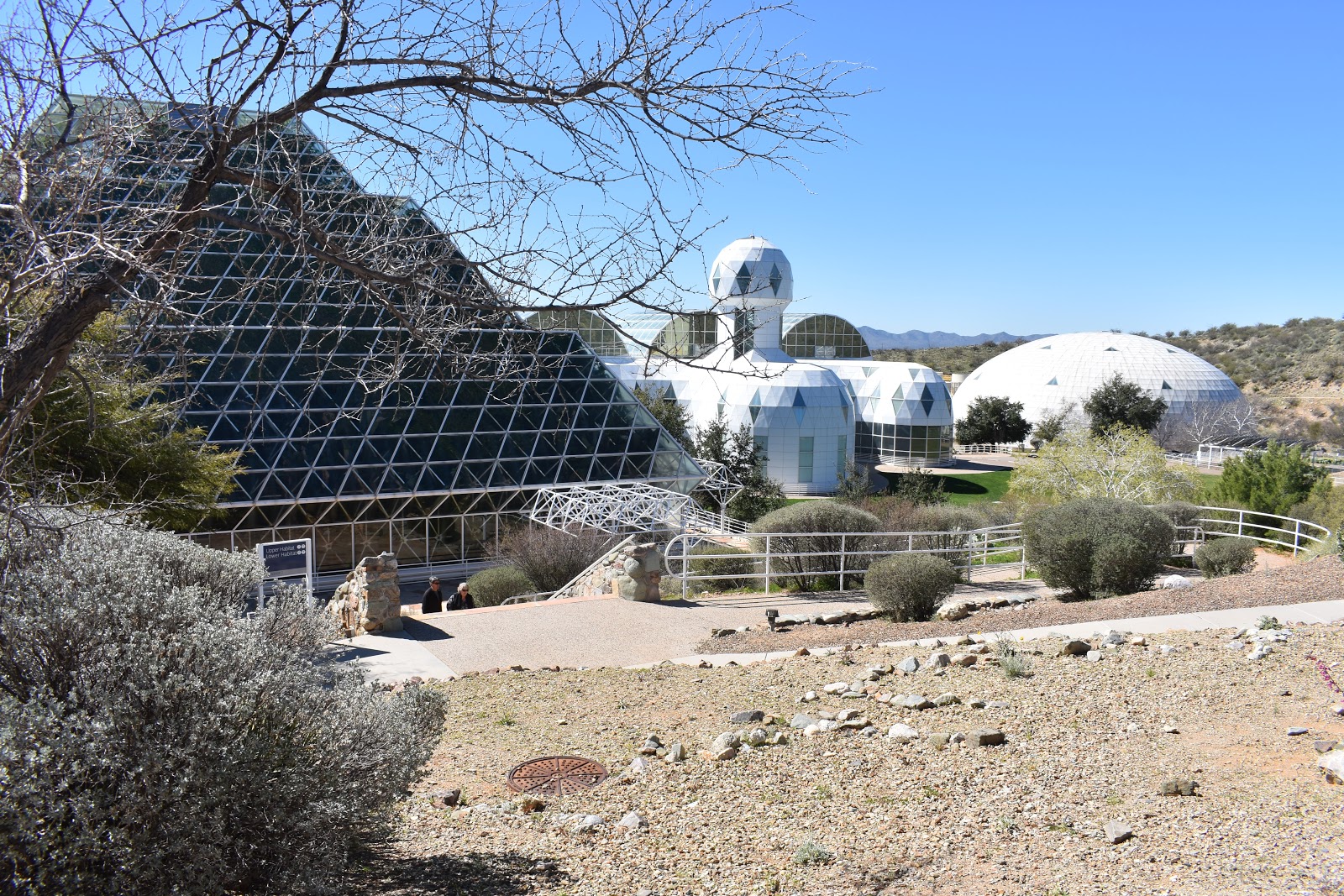
The main reason we went to Tucson was to visit Biosphere 2. Do you know where Biosphere 1 is? Answer at the end of the blog.

Biosphere 2 was built to demonstrate a closed ecological system supporting human life. NASA wanted this for long term space exploration and colonization. Biosphere 2 was only used for this purpose twice. The 1991-93 group consisted of eight people and was marginally successful. The "biospherians" learned that farming was a lot more work than they thought, the vegan diet was boring, and if plants died out, they could find themselves short of food AND oxygen. The group apparently misjudged how much coffee a tree could produce so they went the entire time getting about one cup of coffee every two or three weeks! The entire Biosphere 2 site is now owned and operated by the University of Arizona as a research facility.

The Biosphere 2 was divided into three ecosystems plus a farming area. This was the tropical rain forest. It actually was raining pretty hard when we were there.

This is the "ocean." They claim this is the largest open water research tank in the world, but it looks pretty small compared to the real thing. After the tour was over, we went and explored the viewing area below the ocean tank. It was actually teaming with life and was much more interesting than the top part of the "ocean."

Another ecosystem was this desert. It seemed a little silly to have a "desert" under glass in the middle of the desert.

This was one of two "lungs" for the facility. Since the Biosphere 2 was air tight, there had to be some way to equalize the pressure inside and outside the facility. If not, the glass ceiling would have exploded outwards or collapsed in on itself. The legs on the big round lung are what it sits on when it is completely deflated. They had quite a neat demonstration of this lung deflating when they opened the door to let us out.

In addition to the three ecosystems, there was a farming area and living quarters. The three arched sections on the left were the "farm." Today, they are doing a massive experiment on how sloped areas change over time.

This is another experiment the University of Arizona is conducting. They collect photovoltaic energy from the solar panels and simultaneously grow plants under them. They seem to be finding that the shade allows the plants to require less water (this is a desert!) and still grow as well as they did in full sun.

We went to Saguaro National Park West. The park is divided into east and west sections divided by the city of Tucson. We have never seen so many Saguaro cacti in our lives. If you ever get off the trail, you will regret it! There were some very pretty and extremely evil cacti growing here!

This is a Barrel Cactus. Many of the cacti were blooming at this time.

We visited the Pima Air Museum. It is the largest non-government funded aerospace museum in the world. They are supposed to have over 300 aircraft on display. We got tired of walking past so many planes and didn't see all of them.

Jim loved this WWII era flying boat. Be sure to notice Alonda standing next to it. You may have to zoom in!

Tucson had something called the "Turquoise Trail." It was a self-guided walk (downloadable app available) around some historic sites in downtown Tucson. Sites were numbered along the painted trail.

This was the old courthouse building which has been renovated for other uses. Notice the trail on the left.

We had earlier visited the Southern Arizona Transportation Museum and it turned up on the trail. The Amtrak station has been remodeled to its 1946 appearance and was a stop on the trail.

When traveling, we like to visit small museums. You can see them in a reasonable amount of time! This was Fort Lowell. It was a cavalry post in about 1873. The original Fort Lowell was in downtown Tucson but it was moved outside of town because of complaints from the citizens about the soldiers carousing and drinking. It served as a major supply depot for southern Arizona and operated against the Apache. The National and the Arizona State Daughters of the American Revolution (DAR) funded this hallway exhibit in the museum. The exhibit depicts the life of families at a frontier post.

We visited the "The Mini Time Machine Museum of Miniatures." This is the entrance. You will notice that Jim has his hand on a tiny replica of the giant door on the right.

This was a "small" museum because it specialized in miniatures (think dollhouses done in extreme detail). Individual artists would specialize in some particular item, such as lamps or fine china. Then these items would be collected and assembled to make the room or house.

Enjoy looking at this panoramic view from a hill overlooking Saguaro desert. You might want to zoom in and move it from side to side.
We had a wonderful two weeks. It only rained once!
If you are still wondering where Biosphere 1 is, open your door and walk out into it! Biosphere 1 is Planet Earth!


 The route went through Bremerton and Mt Rainier was up to greet me.
 By the time I got to the Bremerton shipyard, the sun was up.
 The road to Gorst looked like something from a zombie movie. Almost no cars to be seen.
 I rolled over the Old Belfair Road and out along Hood Canal towards Hoodsport.
 The fog rolled back in and there were a lot of people out collecting oysters because of the minus tide.
 My usual Day One total is 115 miles, so at 57.5 miles, I stopped and turned around. The route back was the same as the route out. Not like the real STP!
 I spent the night at home instead of sleeping on the floor of Bethel Church. It was more comfortable, but not as much fun.
 I started Day Two at the usual 5:15 am. I don't think I saw a single car or person before about 6 am. I went through Silverdale and up the Silver Creek Trail to catch Highway 3 north.
 By the time I got to the Hood Canal Bridge, the sun was well and truly up.
 The views along the top of Highway 104 are always great.
 The cows in Chimacum said "Moo!"
 I turned around at Better Living Through Coffee in Port Townsend. They take their masks and social distancing seriously here.
 Center Road on the way back was gorgeous.
 Since Marathon Photo was not at this year's STP, I had to take my own photo in front of a barn. If you have ever done STP, you know what I am talking about.
 I missed the traditional last hill at St Johns Bridge going into Portland so here is the last hill from this year's STP.
 The Portland bike lanes, traffic lights and traffic are always a part of the STP tradition, so here is the Kitsap County version.