The crater is a remnant of a much more violent period in the geologic history of Saudi Arabia. Some people actually question whether or not it is volcanic or the result of a meteor strike. If you know your rocks, it is obviously volcanic in origin. People in the Pacific Northwest know about cones and craters because of Mt St Helens.
 Sunrise over the crater was spectacular.
 Here is Alonda and her bodyguards. We had lots of guards because of the British Consulate people. Also, the area is close to the summer capitol of the country and the King and his entourage can show up at any time. They have to have lots of guards all the time, anyway.
Notice the guards: They wear white thobes (you can't run in a thobe), sandals (ever been in a hurry over rocks in your sandals?), shoulder holsters (any enemy will be a lot further away than a 9mm pistol can shoot), cigarettes (high stress job) and cell phone (have to talk to your friends, don't you?). They didn't actually do a lot of 'guarding'.
 Camping (Saudi style) is not like you remember from the Boy Scouts! Notice the red carpet on the rocks, the truck with the spare Port-a-Pottie and giant tank of water and, of course, the satellite dish. We didn't use the Port-a-Pottie since they permanent buildings in the background had toilets and showers. We are not sure why we slept in a tent.
 Here is the "camp" site with the "bodyguards" outside the fence with their own little camp site. They had to walk all the way in to use the toilet. Really roughing it!
 We walked down into the crater. That is why we came, isn't it?
Walking down doesn't sound that tough, but look at the next couple of pictures. The crater is about 500 meters deep. That isn't much until you realize that is over 1/4 mile straight down! It got quite hot hiking back out.
 Here are some of the major features of the crater.
 Here is the same picture without the writing on it.
 This is the escarpment on the southwest side of the crater. The hole is about a mile across. We aren't sure and haven't found it on GoogleEarth yet.
 This is the actual trail down into the crater. If you click on the picture, it is supposed to open in a new window at full size. Can you find the human figures on the trail?
 Even though the crater is an extinct volcano and is surrounded by cinder cones, there is life here. We found this Desert Wheatear nesting and eating in this berry bush. Looked like currants, but we didn't taste them! We saw some swifts and Desert Larks, too.
 This is what we found in part of the bottom of the crater. The bubbles are formed by soda, salt and water. That is what you put in chocolate chip cookies to make them rise and it works for mud, too! The desert has very little rain, but that doesn't mean NO rain.
 These are what are known as "Saudi Diamonds". In reality, it is obsidian and malachite crystals. There are some other varieties which are quartz and polish up nicely, but we prefer the real thing!
 Traditional sunset picture. The End.


 A truly relaxing way to see the city is to take the Staten Island Ferry. The views are spectacular and it is free. There are always large numbers of tourists, even though it was the middle of winter.
 Arabian Natural History Society. We flew to Medinah (second holiest site in Islam) and then rode a bus for six hours to the town.
 This is the setting for the town and hotel. The Bedouin tents belong to the hotel and you can rent them and stay in them (if you want!). Look closely and you will see the built-in air conditioner! The sandstone escarpment hangs all around the town.
 This is what we went to see. The tombs! The people at the base and standing on top will give you an idea of the size of the rocks. Notice the honeycomb effect where the sandstone has been worn away. They weren’t carving granite!
 This is Jim’s favorite shot. The coloring just came out looking really cool. This is the single largest tomb. Don’t be fooled, though. The rock is really large, but the interior is one, unfinished, very small room.
 This is Train Station No. 21. The Turks used to run the area and ran a train from Istanbul to Riyadh (current capital of Saudi Arabia). During WWI, Lawrence of Arabia managed to wreck the tracks (watch the movie!). This is where the train came through and the wrecked train is still out in the desert. We didn’t get to go visit it, but hear it has been picked clean by souvenir hunters.
 This is the actual station. The light poles are new, but the rest of the place is original from the Turks. Apparently, someone wanted to do some tourism, but got no further than some light poles! Saudi Arabia still only issues about 500 tourist visas per year for the country.
 This is THE industry around Mada’in Saleh. Date palms. Except for a (very) few tourists, there is nothing else here.
 In the foreground, you can see the original old town. Yes, it is mud, logs and palm leaves. Between 30 and 40 years ago, the Saudi government built an entire new city for the inhabitants and they abandoned the old town. Forty years of neglect and the mud is still standing. Not a lot of rain. Along the new city, you can see why the date palms grow here. Fog brings in a significant amount of moisture. You can’t see it, but along the bases of the date palms is evidence of actual water on the surface. The city actually has some serious storm ditches. When it rains, they get some real gully washers thundering down from the hills.
 Great shot of Alonda down in the middle of the old town. Part of it is being renovated with an eye to tourism in the future.
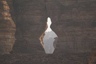 “The Bowling Pin” gives you an idea of how the sandstone can be worn away into just about any shape you can imagine.
  “Elephant Rock” takes little imagination. Notice our bus and the car. A LOT of sandstone has been worn away in this area.
 Our guide managed to look good no matter where he was standing. The “campfire” represented about 15 minutes of fuel gathering. Not a lot grows out there.
 Sunset. The next day we rode the bus for four hours and flew home.

